Marlborough Sounds Reserves
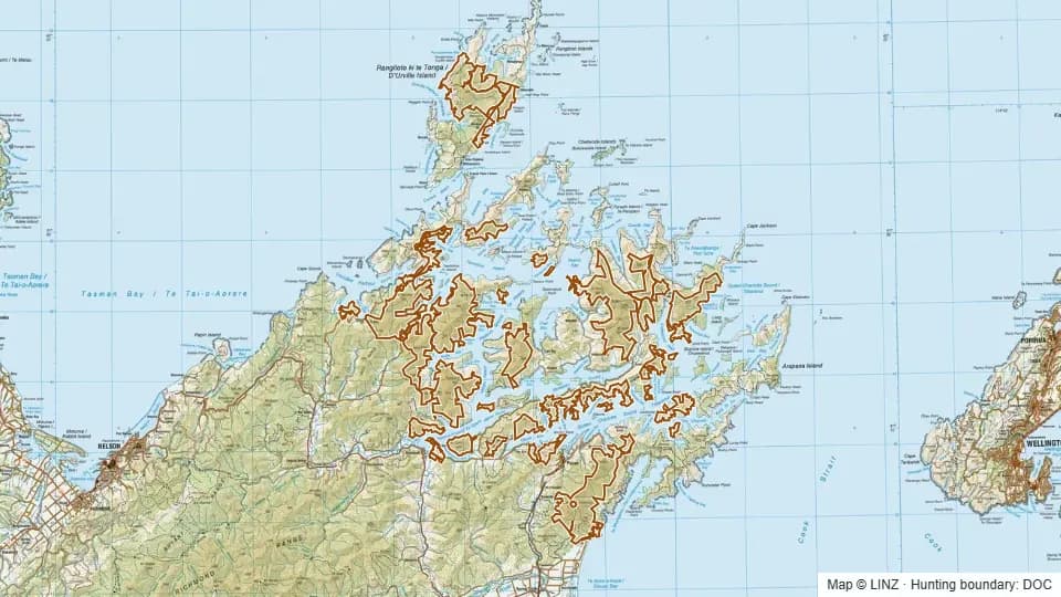
Marlborough Sounds Reserves covers 143,311 hectares of scattered public conservation land through the Marlborough Sounds — a sprawling network of scenic reserves, conservation areas and public conservation land covering peninsulas, bays and ridge systems around Queen Charlotte, Pelorus and Kenepuru.
Elevations run from sea level to 1,199 m with a median of just 297 m, putting the bulk of this country in the lowland and foothill bracket. Expect coastal beech and broadleaf bush, ridge spurs running down to the water, and a strong south-east aspect lean on the main faces. This is bush hunting in coastal country, not tops work.
The Sounds carry red deer, fallow deer, wild goat and wild pig. Fallow are a particular feature of the Sounds, with established populations through several of the peninsulas. The mosaic of bush, regenerating scrub and pasture edges suits all four species, though access is the defining challenge.
Open Marlborough Sounds Reserves on the interactive map
Boundary, huts, terrain, tracks and 1080 zones — all layers, one map.
Terrain & elevation
Based on a sample of 143,724 DEM points inside the block.
- Elevation range
- -2–1,199 m
- Median elevation
- 297 m
- Middle 50%
- 154–474 m
- Above bushline (1,200 m)
- 0%
- Alpine (1,500 m+)
- 0%
- Dominant aspect
- south-east-facing
-2–1,199 m, foothill country with low tops, leaning south-east-facing.
What you can hunt here
Access & getting there
Air access is not permitted on these blocks, but WARO is permitted, so commercial recovery operations may run over parts of the country. Most practical access is by boat — many of the reserves and conservation areas have water access points and short tracks running inland from the shore.
No DOC huts are listed inside the hunting blocks themselves, so plan for boat-based trips, camp set-ups on the shore, or day hunts off a boat base. Track networks vary widely between reserves; check the latest DOC information for each specific area before committing to a route, and confirm any private-land surroundings.
Huts & campsites
Campsites: Moawhitu Campsite, South Arm Campsite, Lucky Bay Campsite, Kauauroa Bay Campsite, Cowshed Bay Campsite, Whites Bay Campsite, Bay Of Many Coves Campsite, Black Rock Campsite, Kumutoto Bay Campsite, Waiona Bay Campsite, Penguin Bay Campsite, Putanui Point Campsite, Davies Bay Campsite, Mill Arm Campsite, Waimaru Campsite, Mistletoe Bay Campsite, Harvey Bay Campsite, Jacobs Bay Campsite.
Permits & rules
You need a DOC hunting permit to hunt this block. It is classed as a Ordinary block in the Marlborough Sounds permit area, with a hunting status of Permitted.
Commercial wild-animal recovery (WARO) operates over this area — expect helicopter activity and pressured game.
Marlborough Sounds Reserves is an Ordinary permit area with Permitted hunt status, covering hundreds of separate parcels of public conservation land across the Sounds. A standard DOC hunting permit applies year-round, but hunters should check the specific reserve before each trip — some smaller scenic reserves have additional restrictions or closures, and adjoining private land complicates access in many areas.
1080 & pesticide status
No laid, planned or proposed pesticide operations intersected this block in our data. Always confirm with DOC before taking a dog in.
Data snapshot: 26 May 2026 — always reconfirm with DOC before relying on this.
Get roar & 1080 alerts for the areas you hunt
We'll email you when pesticide operations, ballot dates or access conditions change for Marlborough.
Sign up →